Intensity Lab Intensity Reports
Intensity reports produced by the Intensity Lab site are based on USGS ShakeMap information. Currently, the Intensity Lab only produces site-specific intensity reports once a USGS ShakeMap has been posted online for a California earthquake. Since the USGS usually only produces ShakeMaps for Magnitude 3.5 and larger earthquakes, the Intensity Lab typically only generates intensity reports for Magnitude 3.5+ events.Once a USGS ShakeMap exists for an earthquake, the Intensity Lab retrieves the ShakeMap intensity data. Then we select California cities near the earthquake epicenter, and calculate the seismic intensity for the cities using ShakeMap intensity estimates. We interpolate ShakeMap intensity values to find an intensity estimate for each city of interest. We round fractional intensity values to the nearest integer.
Once the Intensity Lab system has identified one or more California cities that might have been affected by the earthquake, we format a event summary message that describes the earthquake magnitude, Location, and origin time. We then create site-specific intensity reports for cities near the epicenter, and then report the USGS Event ID, the city name, the epicentral distance, and the estimate intensity for that city.
Intensity Lab site-specific intensity reports currently do not contain the earthquake magnitude, or the earthquake time. Seismic Intensity reports are linked to the earthquake causing the ground mootins through the USGS Event ID.
To determine the number of intensity reports to send for each earthquake, we use two criteria. First, we send out intensity reports for all cities in our city list with intensity estimates of Intensity Four (IV), or higher. For a large earthquake, in a densely populated area, we may generate intensity reports for many cities. We also set a minimum number of intensity reports, currently set to 5. We report all cities at intensity level Four (IV), and then add cities close to the epicenter until we report on at least 5 cities.
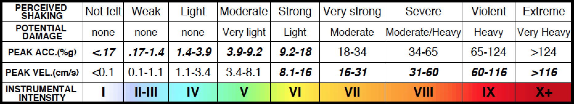
USGS ShakeMaps are based on instrumental intensities. This means the intensity levels reported on ShakeMaps are derived from ground motion instrumental measurements, and they are not based human observations of ground motions. This is one, of many, reasons that Intensity Lab intensity estimates may be inaccurate, so only use Intensity Lab reports for informational and educational purposes.
California City List
Intensity Lab seismic intensity reports are based USGS ShakeMap information, and on a list of significant cities in California. After an earthquake, we look up nearby California cities, and send out an estimate of the seismic intensity in each of those cities.
The list of California cities we report on are listed on our:
If your city or town is not included in the list, you can send your city to us at the email address below, and we may include your city or town in future intensity reports.The Intensity Lab Email Contact:
info@intensitylab.com