Most Recent Google Earth KMZ Intensity Map Tours
- Earthquake USGS ID: #ci37374890: M 3.6 - 3km ENE of Calimesa, CA on Sun Sep 30 07:41:29 2018 PDT
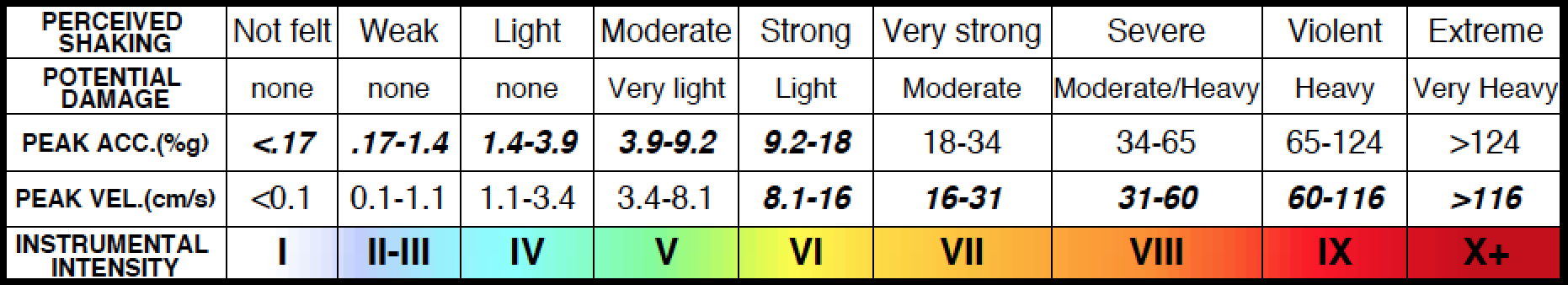
- #Calimesa #intensity : Four (IV) - Widely Observed Shaking located 3km (2mi) from #earthquake USGS ID #ci37374890 : Download Google Earth Tour
- #Beaumont #intensity : Four (IV) - Widely Observed Shaking located 8km (5mi) from #earthquake USGS ID #ci37374890 : Download Google Earth Tour
- #Yucaipa #intensity : Three (III) - Weak Shaking located 4km (2mi) from #earthquake USGS ID #ci37374890 : Download Google Earth Tour
- #Banning #intensity : Three (III) - Weak Shaking located 15km (9mi) from #earthquake USGS ID #ci37374890 : Download Google Earth Tour
- #Redlands #intensity : Three (III) - Weak Shaking located 16km (10mi) from #earthquake USGS ID #ci37374890 : Download Google Earth Tour
Earlier Google Earth KMZ Intensity Map Tours
- Earthquake USGS ID: #ci37373442: M 4.4 - 9km NNW of Delta, B.C., MX on Fri Sep 28 19:17:48 2018 PDT
- #Calexico #intensity : Three (III) - Weak Shaking located 37km (23mi) from #earthquake USGS ID #ci37373442 : Download Google Earth Tour
- #Holtville #intensity : Two (II) - Scarcely Felt Shaking located 45km (28mi) from #earthquake USGS ID #ci37373442 : Download Google Earth Tour
- #ElCentro #intensity : Two (II) - Scarcely Felt Shaking located 51km (31mi) from #earthquake USGS ID #ci37373442 : Download Google Earth Tour
- #Imperial #intensity : Two (II) - Scarcely Felt Shaking located 56km (35mi) from #earthquake USGS ID #ci37373442 : Download Google Earth Tour
- #Brawley #intensity : One (I) - Not Felt located 67km (41mi) from #earthquake USGS ID #ci37373442 : Download Google Earth Tour
Viewing KMZ Files
After significant earthquakes, the Intensity Lab produces Google Earth Tours, in KMZ format, of the epicenter and nearby sites of interest. Recent Intensity Lab Google Earth KMZ Intensity Map tours are provided above.
The KMZ files, linked to above, can be downloaded to your computer. Then, they can be viewed using Google Earth software, available free from Google. The Intensity Lab KMZ tours start in a location over California, zoom into the epicenteral region of the earthquake, then fly to a city near the epicenter. The tour shows a USGS ShakeMap intensity map for the region. Text descriptions in the KMZ tour for the earthquake epicenter, and the selected city, describe the earthquake magnitude, and the estimated intensity for the selected city.
Intensity Lab KMZ files are similar to USGS KMZ files, but Intensity Lab KMZ Google Earth tours report site-oriented intensity. The USGS KMZ files report primarily on earthquake location and magnitude. The USGS instruction for opening and viewing KML and KMZ files are on the USGS web site: