Max Est. MMI
M5.0 earthquake · shaking intensity by town 10 km NW of Pinnacles, CA
Seismic Waves Across the Region
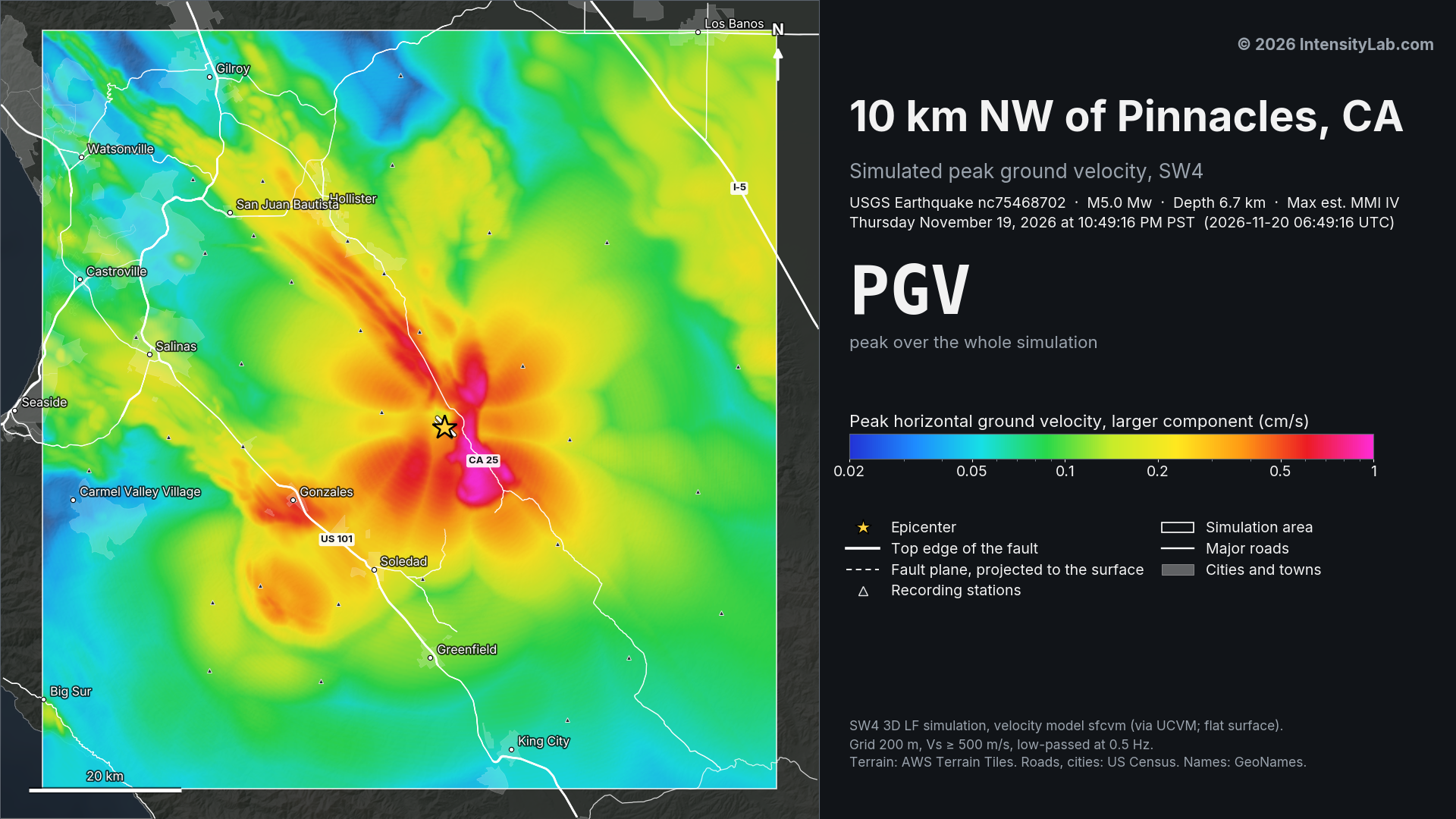
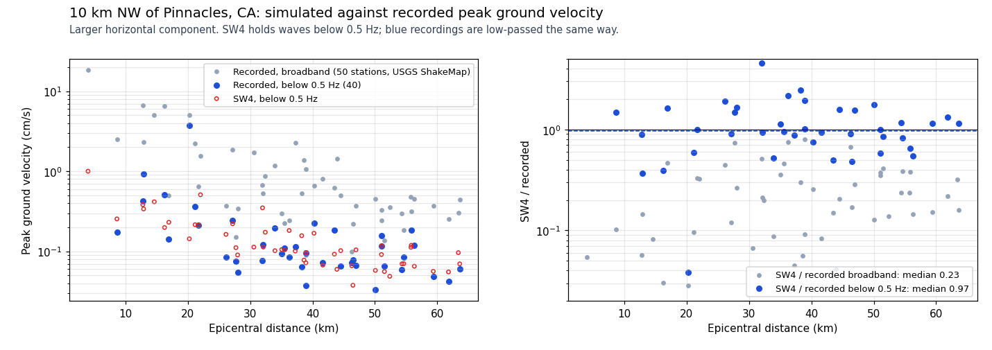
A simulation of this earthquake’s waves crossing the region (SW4, through the bbpservices.net API). The model is the USGS San Francisco Bay Area velocity model (SFCVM v21.1), which includes the region’s sedimentary basins, so the movies show waves slowed, trapped and amplified in them. The surface is flat, and the simulation holds waves below 0.5 Hz only. Regional and the two seismogram movies show ground velocity at the surface moment by moment, then end on the peak ground velocity map. In Regional with seismograms on map, each of six sites traces its simulated seismogram from the moment the earthquake starts, all on one scale, so you can watch the shaking weaken with distance. Regional peak velocity shows each place keeping the strongest velocity it has reached. Velocities are not converted to intensity.
Engineering Ground Motion Parameters
GMPE predictions provide an independent check on the ShakeMap interpolated intensities above.
ShakeMap relies on seismic station recordings; in areas with sparse station coverage (or
for large teleseismic events and earthquakes outside dense West Coast networks), ShakeMap
MMI can be inaccurate. A significant difference between ShakeMap and GMPE estimates is a signal
that the ShakeMap result should be treated as preliminary.
Also includes site Vs30 values and raw ground motion parameters (PGA/PGV).
Show ▼
Engineering Ground Motion Parameters
GMPE predictions provide an independent check on the ShakeMap interpolated intensities above. ShakeMap relies on seismic station recordings; in areas with sparse station coverage (or for large teleseismic events and earthquakes outside dense West Coast networks), ShakeMap MMI can be inaccurate. A significant difference between ShakeMap and GMPE estimates is a signal that the ShakeMap result should be treated as preliminary. Also includes site Vs30 values and raw ground motion parameters (PGA/PGV).
Est. Vs30 Values
Estimated shear-wave velocity in the upper 30 m used in GMPE calculations. Ref. column shows the 760 m/s rock-site reference for comparison.
| Location | Ref. (760 m/s) | Est. Vs30 (m/s) |
|---|---|---|
|
Soledad
CA |
760 | 231 |
|
Greenfield
CA |
760 | 294 |
|
Gonzales
CA |
760 | 228 |
|
King City
CA |
760 | 294 |
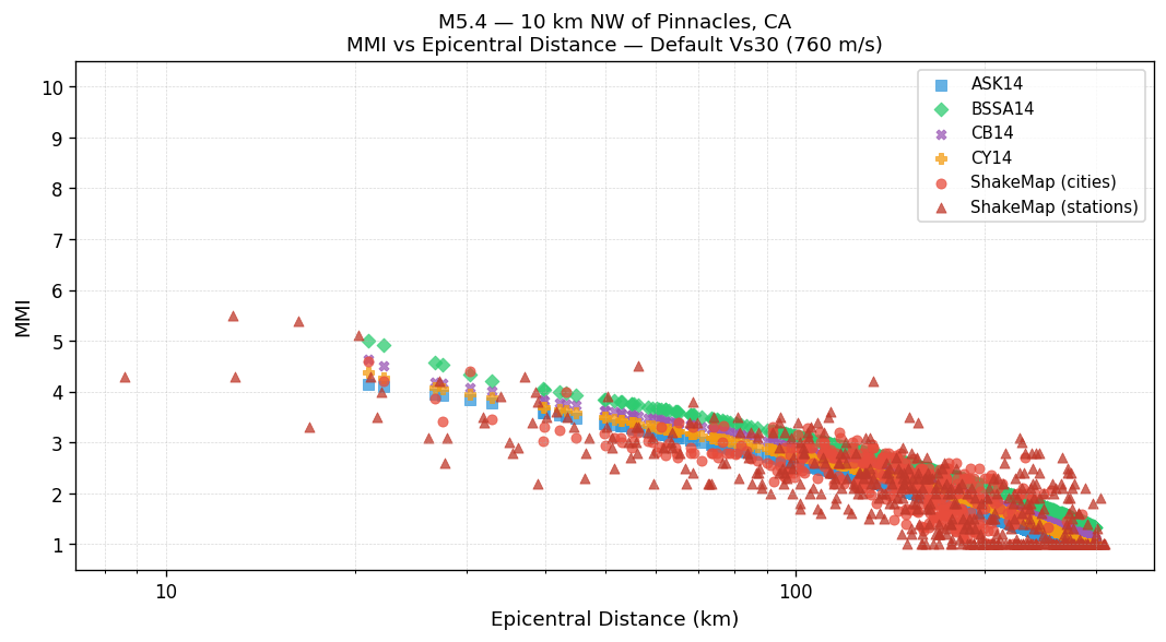
MMI vs Distance: Default Vs30 (760 m/s)
All methods using the 760 m/s rock-site reference. ShakeMap values are independent of Vs30.
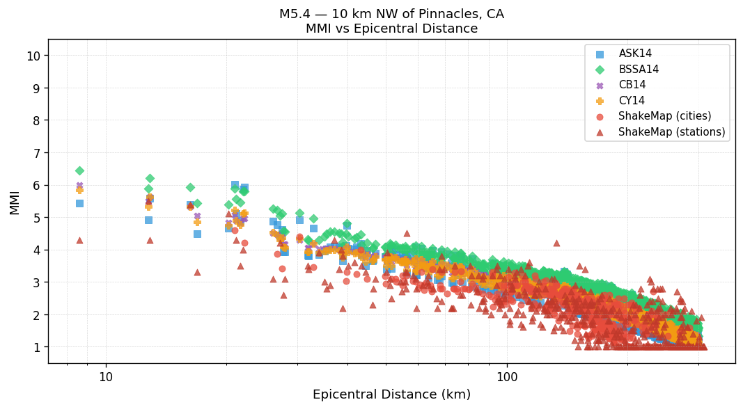
MMI vs Distance: Est. Vs30
GMPEs use the Est. Vs30 values shown in the table above. ShakeMap values are independent of Vs30.
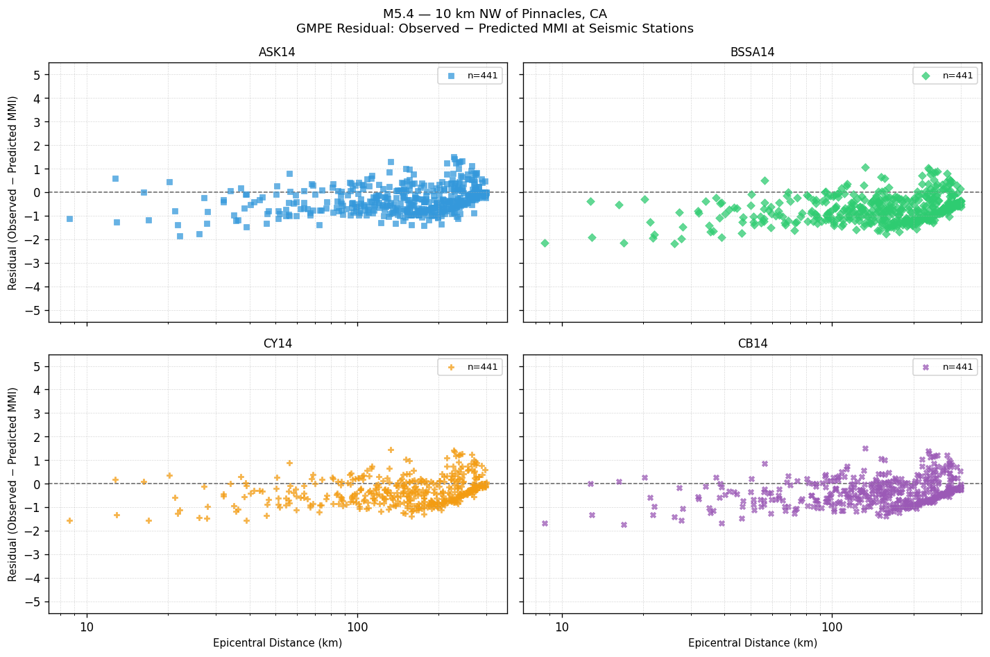
GMPE Residual: Observed − Predicted MMI
Signed residual at each seismic station. Positive values mean the GMPE underestimated shaking; negative values mean it overestimated. The dashed line at zero indicates perfect agreement.
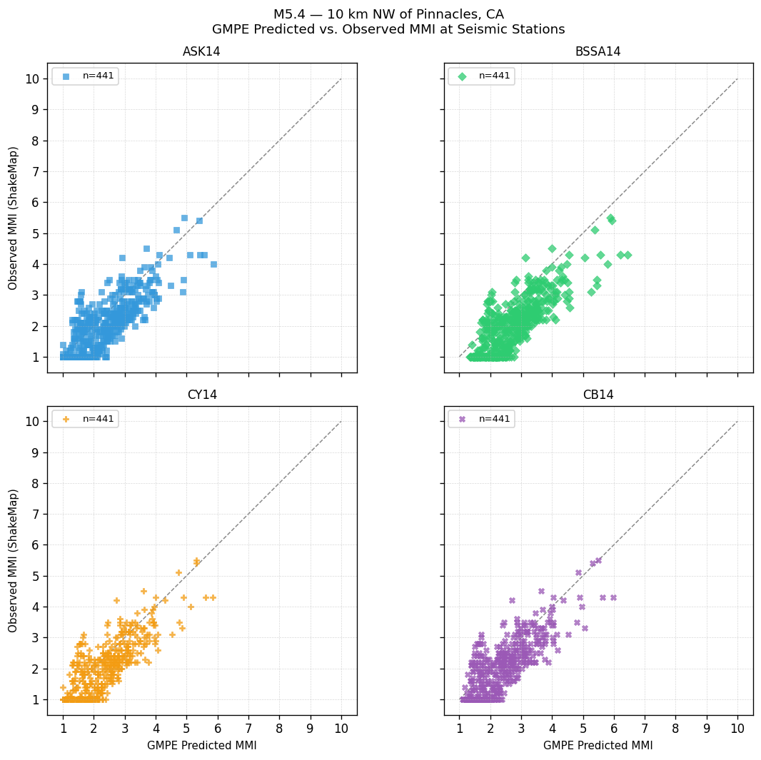
GMPE Predicted vs. Observed MMI at Seismic Stations
Each point is one seismic station. Points on the dashed 1:1 line indicate perfect agreement; above the line = GMPE underestimated shaking; below = overestimated.
GMPE Performance: Station Observations
Statistics computed by comparing each GMPE's predicted MMI against ShakeMap observed MMI at seismic stations. Bias = mean(observed − predicted). Lower RMSE indicates better overall agreement with instrumental measurements.
| GMPE | Bias | Sigma | RMSE |
|---|---|---|---|
| ASK14 | -0.31 | 0.57 | 0.65 |
| BSSA14 | -0.71 | 0.56 | 0.91 |
| CY14 | -0.31 | 0.56 | 0.64 |
| CB14 | -0.35 | 0.56 | 0.67 |
Peak Ground Motion: Seismic Station Observations
Recorded PGA and PGV at seismic stations, sorted by highest PGA. Top 25 stations shown. MMI (PGA) and MMI (PGV) are independent conversions via Worden et al. (2012) GMICE.
| Station | PGA (g) | MMI (PGA) | PGV (cm/s) | MMI (PGV) |
|---|---|---|---|---|
| Big Mountain #3 (NC.BBGB) | 0.2062 | Strong(VI) | 6.538 | Moderate(V) |
| Panoche Road (NC.BPA) | 0.1172 | Strong(VI) | 6.684 | Moderate(V) |
| Mount Johnson (NC.BJOB) | 0.0889 | Moderate(V) | 2.498 | Light(IV) |
| Shirttail Gulch (NC.BSG) | 0.0698 | Moderate(V) | 5.072 | Moderate(V) |
| Topo Valley (NC.BTV) | 0.0454 | Light(IV) | 2.242 | Light(IV) |
| Crazy Canyon #3 (NC.PCC) | 0.0439 | Light(IV) | 2.984 | Light(IV) |
| Juan Fiesta (NC.BJF) | 0.0305 | Light(IV) | 2.258 | Light(IV) |
| Hahn Winery (NC.BHW) | 0.0291 | Light(IV) | 1.846 | Light(IV) |
| Lonoak Road 2 (NC.PLOB) | 0.0225 | Weak(III) | 0.803 | Weak(III) |
| Pinnacle Vineyards (NC.BPV) | 0.0224 | Weak(III) | 2.321 | Light(IV) |
| Mercy Hot Springs (NC.BMS) | 0.0215 | Weak(III) | 1.055 | Weak(III) |
| Livermore FS 8 Scenic (NP.1803) | 0.0215 | Weak(III) | – | – |
| Gonzales (CE.47499) | 0.0205 | Weak(III) | 1.567 | Light(IV) |
| Cienega Road (NC.BCGB) | 0.0195 | Weak(III) | 0.498 | Weak(III) |
| Bitterwater Creek (NC.PBC) | 0.0168 | Weak(III) | 1.392 | Light(IV) |
| Salinas Radio Site #2 (NC.BSR) | 0.0165 | Weak(III) | 0.339 | Weak(III) |
| Babies Gulch, Panoche, CA (BK.BABI) | 0.0163 | Weak(III) | 1.172 | Weak(III) |
| The Indians Road (NC.BTI) | 0.0157 | Weak(III) | 0.432 | Weak(III) |
| Palo Escrito (NC.BPE) | 0.0151 | Weak(III) | 0.678 | Weak(III) |
| Peach Tree (NC.PPTB) | 0.0147 | Weak(III) | 1.106 | Weak(III) |
| Le Cuvier Winery, Paso Robles, CA (BK.LCUV) | 0.0134 | Weak(III) | 0.804 | Weak(III) |
| Williams Hill (NC.PWH) | 0.0132 | Weak(III) | 0.707 | Weak(III) |
| Tumey Hills (BK.TUMY) | 0.0123 | Weak(III) | 1.173 | Weak(III) |
| Landels-Hill Big Creek Reserve, Lucia, CA (BK.LAND) | 0.0122 | Weak(III) | 0.549 | Weak(III) |
| San Antonio Reservoir (NC.PAN) | 0.0106 | Weak(III) | 0.646 | Weak(III) |
Ground Shaking Intensities: Interpolated ShakeMap MMI
4 sites| Location | MMI Description |
|---|---|
|
Soledad
CA |
Light(IV) |
|
Greenfield
CA |
Light(IV) |
|
Gonzales
CA |
Light(IV) |
|
King City
CA |
Light(IV) |
Seismic Station Observed MMI
MMI values are derived directly from observed ground motion measurements at seismic stations and are not spatially interpolated.